
Major North American Lakes Simulations for High Quality Continental Climate Change Projections

Author: Dr. Mani Mahdinia
A major focus of the climatology group of C1W has been on producing high-quality North American (NA) continental historic climate and future projections for regional climate modelling simulations. Analysis and refinement of the role of major North American lakes constitutes an influential component of these efforts, as lakes comprise a large and frequently occurring portion of the North American landscape. A less-capable lake model could, for example, under-produce the surrounding urban regions’ precipitation and hence result in an unrealistic water cycle.
Inland water bodies have a significant effect on climate, particularly at a regional scale, for example as heat sinks and sources of moisture. Envision the snow belts east of the respective Laurentian Great Lakes. An important effect on the influence of lakes on winter climate is ice cover, which reduces moisture and temperature transfer between the lake water and atmosphere. Consequently, a major effort has been dedicated to improving the integration of the three largest North American lake regions: the Great Lakes (GL) region; Lakes Winnipeg & Winnipegosis (LWW); and the Great Bear Lake/ Great Slave Lake/Lake Athabasca (GSBLA) region. For each of these regions there are currently three different lake models implemented: i) Weather Research and Forecasting (WRF) default lake model; ii) Great Lakes Environmental Research Laboratory (GLERL) model and iii) FLake model which was added as a potential candidate for improving the simulation quality.
One of the most-widely used and tested models – Flake – outperforms the other models in terms of predicting near-regions’ terrestrial precipitation/surface temperature and lake ice cover and ice-in/-out dates (Figure 1). The more physical model, GLERL-25 (NOAA’s GLERL 25-layers), shows smaller errors in its reproduction of the summer precipitation/surface temperatures. Using these results, an ensemble of appropriate lake models will be implemented within our continental-scale simulations which involve a diverse set of different physical climate model components.
Estimation and improvement of lake model behaviour and quality for climate simulations is of importance to climate modelling research, specially for future projections for which observations (e.g., lake surface temperature) are not available and most, if not all, of the components of the system have to be estimated/modelled.
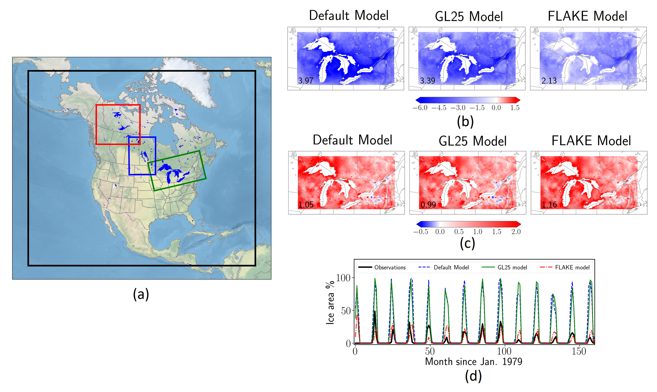
Figure 1. (a) North American (NA) simulation domain shown via thick solid black line and respective lake areas highlighted. The 3 regions from right to left are GL, LWW and GSBLA regions, respectively (see text for the definition of these regions); (b) and (c) Lake model near-ground temperature error (degC) of the three lake models for the Great Lakes region in the winter and summer seasons, respectively (the numbers in the corner of the figures show absolute average error). FLake outperforms other models in winter, GLERL-25 is superior during summer; (d) % of lake area covered by ice for observations and the 3 models. The FLake model has the closest and most consistent match with observational data.